Saturday afternoon update- Morgan
Snow showers and rain/snow mix at sea level has been observed Sunday and this will continue through the remainder of the day. Most favored locations for snowfall with mainly minor accumulations are areas south of Seattle at elevations above about 300 feet, the north coast and Olympic Peninsula, and western Whatcom County.
Elsewhere, including Seattle, Tacoma, and Everett nearer sea level, the combination of slightly warmer temperatures and “snow shadowing” behind the Olympic Mountains will limit precipitation and accumulation.
Still, anywhere snow falls for an extended period of time, accumulations will result. Use caution driving the remainder of the day today and into tonight, when temperatures will fall.
Overall coverage of precipitation tapers into Sunday night and Monday morning, though there will still be some pockets of snow in the lowlands and the mountains. The best chance of snow tonight will be along the coast, south of Tacoma, and possibly western Whatcom County and along the Strait.
Even in spots that don’t have snow tonight and into Monday morning, there could be some icy patches on roads from freezing of water or snowmelt. Drivers should be especially careful early Monday on untreated, side roads and residential streets. It’s expected that main roads should remain fairly good, particularly treated roadways.
Morning lows will be in the 20s. In western Whatcom County, gusty winds out of British Columbia will force wind chills into the single digits early Monday.
While there could still be some spotty snow showers later on Monday morning, it’ll likely be dry in most areas with some breaks of sunshine. Highs will be in the 30s to near 40.
There are chances for spotty flurries or a few very light snow showers Monday night through Wednesday, though it’s expected to not be of any significance for most of the area based on present forecast data. The mountains could pick up some light accumulations. We’ll be watching the week’s forecast details closely as they evolve, as any additional moisture sent our way could increase snow chances some. But for now, it’s looking mainly dry though the week with just some flurries at times through Wednesday.
There could be another chance of snow or rain/snow mix by next weekend, though details are murky.
Saturday late morning update- Morgan
As has been the forecast for many days, the low pressure system spinning offshore in the Pacific will send pockets and bands of rain, snow, and rain/snow mix into Western Washington through the weekend.
Unlike an organized front with heavy precipitation, this spotty nature of precipitation will mean that any impacts from wintry precipitation will be spotty too! Many snow lovers will be disappointed with little to no snow accumulation, though most of us will see flakes fly at times.
Here’s the weather setup for the weekend:
An overnight Puget Sound Convergence Zone put down some areas of slush, sleet, and ice on elevated surfaces in the North Sound, but as this faded Saturday morning, more snow falling in Western Whatcom County is producing some slush on roadways and whitening up of grassy surfaces.
Elsewhere on this Saturday, there will be passing showers of mixed precipitation or wet snow, but with warm southwesterly winds just aloft, this is going to keep the lowlands sufficiently warm that temperatures will reach the upper 30s and lower 40s this afternoon. While any heavier precipitation could “drag down” the snow levels to nearer sea level in isolated showers, any brief accumulations should melt pretty quickly except sticking around a little longer on grassy and elevated surfaces.
Above 500 feet or so in elevation, temperatures will be a little bit cooler and this cooling is more pronounced in locations above about 1,000 feet in elevation. This will allow for showers of rain/snow mix or snow to cause spotty accumulations of snow and slush.
The most favored areas for any accumulation that could cause travel issues will be in foothill locations, Whatcom County, Snohomish and Skagit Counties, along the Strait and the coast (mainly away from the beaches), and any spots above 500 feet in elevation. A Winter Weather Advisory is in effect for most of these areas.
In addition, there is the chance for in isolated lightning strike and hail shower too on Saturday. This could cause brief travel difficulty where ice pellets showers occur. Plus, some sunbreaks at times!
In the mountains, snow showers will continue through the day with more accumulations at times!
There are some signs in forecast data of a tapering of the coverage of precipitation later this Saturday evening into tonight. Not totally rain/snow free, but fewer spots will see precipitation this Saturday evening, before an uptick in the moisture again on Sunday.
Temperatures drop to around freezing by Sunday morning before rebounding into the 30s, so watch out for some slick and slushy spots. Some snow and rain/snow mix showers look to pick back up a bit throughout the day tomorrow. Still, the showery, spotty nature of these passing areas of snow/mixed precipitation make it difficult to isolate specific snowfall amounts for any area, but as with Saturday the better chances will be north of Seattle, in the foothills and adjacent higher elevations (above 300 feet), the coast away from the beaches and also some spots south of Puget Sound.
Locations in the central and south Sound immediately on the water like Seattle and Tacoma have the lowest chance of accumulation throughout this period but folks will see snow!
Through early Sunday evening, we’ll have some melting where wet snow falls in the lowlands and also some moisture from rain. But then temperatures fall. We will have some icy patches by Monday morning as temperatures drop a bit below freezing, so drivers beware. We’ll also have a better chance for any lowland snow to actually stick around for a while, creating minor accumulations.
I anticipate there’s a good chance of some school delays and possibly closures Monday, though that will be far more the exception than the rule. We will have you covered on the morning commute and school delays on KIRO 7 News in the Morning Monday from 4:30 a.m.
For Monday, the most likely areas to have impact from snow and icy roads will again be in the previously-mentioned areas of the foothills of the Cascades, Eastside communities (especially above a few hundred feet elevation), parts of the North Sound (especially from South Everett east through Lake Stevens and south to Snohomish and Mill Creek), Western Whatcom County and the San Juans and western Skagit County and the coast and Strait.
It continues to be important to note that while most of the area will not have significant snowy or icy travel through this period, most locations will have precipitation of some sort — be it rain, a rain/snow mix, or lightly-or-non accumulating snow. Be careful out driving because even if temperatures are above freezing, heavier precipitation that includes wet snow could cause slippery and slushy travel.
Through Monday afternoon, a very slow drying trend is noted but the precipitation type on Monday is more likely to be all snow. However, further accumulations after Monday morning should be mainly light and isolated. Highs will only be in the 30s. A few flurries are likely Tuesday with lows in the 20s and highs in the 30s.
While we maintain a mainly dry forecast the remainder of the week beyond next Tuesday, there could be further chances for light snow we will evaluate as new data come in. This forecast for later next week is very uncertain.
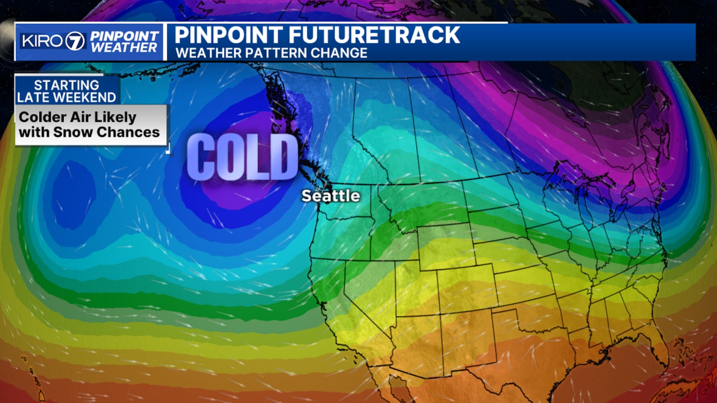
It is likely to be quite cold from Tuesday through Friday with morning lows in the teens to mid-20s and highs in the low-to-mid 30s. This cold will be dangerous for the unhoused.
Also, be thinking and acting now about how you will keep your exposed exterior faucets and pipes protected, and make sure pets and animals have a warm place to be. Also, make sure (if able) to check on neighbors who might have trouble with heat.
Friday Morning - Nick
Happy Friday! It is a PinPoint Alert Day today with widespread rain moving through this morning, with some places already above 1/4″ of rain after two weeks of dry weather! Rain will continue for most of the day with increasingly breezy weather and mild temperatures. Rain will be heaviest south of Seattle, but everyone can expect rain to continue until this evening. The southwesterly wind will bring the snow level up a bit today, but the mountains will still get hit hard.
The Winter Storm Warning is in effect through Saturday above 3,000′. Total snowfall from this winter storm could be give or take a foot at Snoqualmie Pass, and give or take two feet at Stevens and Mt. Baker. Snoqualmie Pass will turn to rain for a good part of today and then turn back to snow late tonight. Travel conditions could be a mess at times, so please take your time and be careful.
Once the cold front moves through later today, onshore wind will increase and be in the Wind Advisory category around the Admiralty Inlet with gusts around 50 mph. That onshore wind and increasingly cold air will produce a Puget Sound Convergence Zone and lower our snow levels for the rest of the weekend. With the presence of cold air moving south from British Columbia, snow levels drop to about 500′ on Saturday, even lower by Sunday morning. This cold air will turn existing moisture into lowland snow.
A Puget Sound Convergence Zone increases the chance of accumulating snowfall Friday night into Saturday morning. This happens because the converging wind will increase the updraft speed and intensity of the showers — and heavy showers can quite literally drag the snow level closer to the surface. The latest computer models suggest this PSCZ is potent and could significantly increase snow totals from roughly the King/Snohomish County line north. This is our best bet for accumulating snow tonight and tomorrow morning, with scattered snow/wet snow showers for the rest of the area.
We also have a Winter Storm Watch for the Coast, parts of the North Interior, and the Cascade Foothills — where around 2-6″ of snow could fall. Most of the area will see plenty of snow and wet snow showers, but accumulation will truly depend on the intensity of the showers and the timing. Highs will be around the upper-30s and lower-40s during the day with a much colder overnight low. That means if we see spotty showers during the day on Saturday and Sunday, I’m sure there will be some snow/wet snow mixed in. However, the low-level wind will stay south/southwesterly, which is literally a snow killer. The south wind will keep our low-level temps too warm for a ton of accumulation. Plus, the showers will be super spotty. All of that said, this is a messy weekend and an even messier forecast with a little bit of everything possible all over, even with some thunderstorms possible at the coast late tonight. If you are under a briefly heavier shower (convergence zone), you may have some spotty accumulation and then see a break in the precipitation before another band moves through that’s not as heavy.
The showers will be spotty tomorrow, Sunday, and Monday with the air getting a little cooler each day. That means we’ll have a slightly better chance for more accumulation on Sunday and Monday. Highs will be in the mid-30s by Monday, and then as we dry out, it will be much colder next week. Highs will just barely get above freezing.
This is a very fluid and tricky situation. Truly, one band of showers at 300′ may produce a quick inch of snow for one neighborhood, which then produces rain a bit lower down the road. Watch for the areas under the Winter Storm Watch, keep an eye on the Puget Sound Convergence Zone, and be ready for spotty showers overnight to fall as snow and or wet snow.
With all of this moisture, Monday morning may be icy as well. We’ll keep you updated on all of this!
Thursday Evening - Morgan
Rain is beginning across Western Washington for the first time in more than two weeks on Thursday night, while temperatures will remain steady into early Friday, rainfall rates could be heavy enough overnight for standing water on some roads.
In the mountains, however, it will be a different story. A Winter Storm Warning has been issued Thursday night through early Saturday for the Cascades above 3,000 feet. Snow will begin even at Snoqualmie Pass by midnight Friday morning and continue into the early daytime hours of Friday, but precipitation along I-90 will likely turn to rain during much of the day on Friday before turning back to snow Friday night. At higher elevations, including Stevens Pass, we’ll likely be all snow through the period. Snowfall totals of one to two feet are likely through Saturday morning in the Cascades, though rainfall at Snoqualmie Pass could cut down on those amounts there. Isolated higher totals of more than two feet are possible on the volcanoes.
The forecast for lowland snow is coming into somewhat better focus, and a Winter Storm Watch has been issued for some locations Saturday night through Monday. As expected, this is not going to be a widespread, major snow event as moisture is going to be limited through the weekend into early next week. But there will be some spots with accumulations that could cause some delays and disruptions.
Saturday will be fairly mild, with high temperatures above freezing for most lowland locations. Showers of rain, rain/snow mix, and wet snow will move through the region. The most probable areas for some minor lowland accumulations (mainly brief) will be along the coast, the Strait, western Whatcom County, and also in any heavier showers in a Puget Sound convergence zone in the North Sound. Also, some minor accumulations of a couple inches are likely to be spotty in the foothills mainly above 750-1000 feet in elevation, as well as the mountains.
Saturday night through Sunday temperatures will be cooling a bit more with snow levels dropping down to about 300 feet by Sunday morning and even lower at the coast, the Strait, and from about Everett north. However, through the day, we’ll still be having just spotty showers of rain/snow mix and wet snow moving through. In locations where we get precipitation to fall for a while, we could see an inch or two of accumulations. However, at the coast, the Strait and the north interior, we could get some areas with somewhat heavier accumulation on Sunday. Locations from about Seattle south through Tacoma and west to Bremerton and Port Orchard are least likely to have snow accumulations except on higher hills, where there could be some slush.
Sunday night and Monday morning is a time period when we could see a few more issues with slippery roads and some snow. The previously-mentioned areas of the North Sound, north interior, the Strait and the Coast are most likely to have a few inches of accumulation – with the north coast and west of Port Angeles possibly getting much heavier amounts of more than six inches. The foothills of the Cascades and nearby areas, including the Eastside, could have a few inches of snow by Monday morning, causing problems for the morning commute Monday.
Unfortunately with this type of event, exact locations where lowland accumulations could happen cannot be fully known until the event is underway, because individual snow showers or narrow bands of snow in some locations will cause snowfall, while areas nearby that do not get hit with precipitation will miss out.
While we have several days where we will “see” snow in many areas, we’re more likely to have most snow lovers in the lowlands disappointed instead of satisfied!
We’ll be monitoring this as we continue to go through the next few days and the weekend. Beyond Monday morning, we are likely to see eventual drying but some light snow showers and flurries are possible through Tuesday morning.
Next week will be very cold once we dry out with highs barely above freezing Tuesday through Thursday and morning lows in the lowlands in the teens to mid-20s.
Prepare now, not only for the chances for snow but also very cold days next week.
Thursday Morning - Frankie
We are less than 24 hours away from the start of our first Pinpoint Alert Day. The forecast remains on track, but with more insight into what could manifest this weekend and the impact it will have heading into next week, I have decided to extend our Pinpoint Alert Day through Monday.
Melting snow, spotty accumulation, and below-freezing morning temperatures would affect some morning commutes and could also delay some school districts, especially areas around the foothills and Snohomish County north, where snow accumulation is more probable this weekend.
Wednesday Evening - Morgan
Friday will be a Pinpoint Alert Day because of the combination of heavy rain, gusty winds, and mountain snow.
Saturday and Sunday are also Pinpoint Alert Days because of colder temperatures and the chance for snow and wet snow showers in the lowlands with spotty, mainly light snow accumulations.
Here’s the weather setup:
A low pressure system developing out in the Pacific Ocean will move into the region Thursday night well after dark, spreading rain into the area. By Friday morning, we’ll be getting some southerly and southwesterly wind gusts of 20-30 mph with isolated wind gusts to 40 mph – especially near the water. These gusty winds will be accompanied by continued heavy rain at times, with rainfall totals in the lowlands in the one-half to one inch range in the lowlands, and more in the mountains. It has been more than two weeks since rain in Western Washington and more than three weeks since heavy rain, so roadways might be a little slick as rain begins. Temperatures on Friday in the lowlands will be mild in the upper 40s to near 50, so there won’t be any chance of lowland snow Friday.
In the mountains, however, it will be a different story. A Winter Storm Watch has been issued Thursday night through early Saturday for the Cascades above 3,000 feet. Snow will begin even at Snoqualmie Pass by midnight Friday morning and continue into the early daytime hours of Friday, but precipitation along I-90 will likely turn to rain during much of the day on Friday before turning back to snow Friday night. At higher elevations, including Stevens Pass, we’ll likely be all snow through the period. Snowfall totals of one to two feet are likely through Saturday morning in the Cascades, though rainfall at Snoqualmie Pass could cut down on those amounts there. Isolated higher totals of more than two feet are possible on the volcanoes.
The heavy precipitation comes to an end early Saturday morning and some colder air slowly filters into Western Washington. At the same time, a low pressure system will move southwestward out of British Columbia into the offshore waters west of our coast. This low will remain in the same general area Saturday through Sunday before slowly sinking south. The counterclockwise flow around this low will send some moisture into Western Washington from the southwest while chilly air filters in from Canada. This combination is most likely to set off occasional showers of wet snow, rain, or snow. Temperatures in the lowlands will likely not be quite cold enough for any snow accumulation during the day on Saturday with the snow levels around 500 feet. Saturday night into Sunday, snow levels fall closer to 200 feet or even lower, though moisture for precipitation will be spotty and thus any potential impacts will be as well. Temperatures in the daytime will be above freezing in most lowland locations, so accumulations during these times are most likely to be brief.
The most probable areas to see minor accumulations (two inches or less) would be under any Puget Sound Convergence Zone that develops in the central or north Sound and also in western Whatcom County and the San Juans closer to the source of cold air from British Columbia. Also, we’ll watch the eastern Strait around Port Angeles for snow accumulation. Elsewhere, it is most probable that we just see some wet snow with little to no accumulation.
However, on such a “marginal” situation for lowland snow in Western Washington, we will be monitoring the conditions as they develop. But there remains no indication that a significant lowland snow event is on the way this weekend.
Beyond the weekend and throughout much of next week, we will likely be cold enough for lowland snow (highs in the 30s and lows in the 20s) but the amount of moisture and timing of any precipitation is unknown at this time. We will be on watch for any further weather systems that could bring disruptive weather. The mountains will continue to get snow at times.
Wednesday Morning - Nick
Computer models continue to have a tough time with our weekend forecast. It does look likely that our temps are going to cool off even more, with snow levels on Saturday and especially Sunday and Monday, closer to the surface.
Saturday may be around the surface to 500′, unless we have heavy showers.
In fact, I think that our best bet for scattered snow or wet snow showers Saturday will be with the Puget Sound Convergence Zone.
It’s a very marginal event at this point, but the Convergence Zone can produce showers heavy enough that the snow level quite literally is forced lower to the surface and can produce snow.
We’ll continue to watch the incoming computer model data, to see if the models begin to agree. With temps the way they are predicted to be and with the scattered moisture, I think a lot of people will see snow in the air, but it may not build up a ton. Stay tuned.
Tuesday Evening - Morgan
We continue to see disagreement in the forecast data tonight regarding weekend snowfall accumulation (if and where that happens) but that’s not at all unusual this many days away. We will have to likely wait several more days before we get a good lock on the details. Why? It appears that while it’ll be colder Saturday and especially Saturday night and Sunday morning, just how cold we get and how much moisture is available for precipitation are uncertain.
If temperatures in lowland spots are in the upper 30s on Sunday (for example), then we might “see” wet snow but have little to no accumulation unless a heavier band of precipitation shows up -- like a Puget Sound Convergence Zone. If it’s just a few degrees cooler, then there would be a better chance for light accumulations. A few degrees of temperature difference simply is impossible to determine five or six days out. Throw in our varied terrain of Western Washington, with influence in some spots from relatively-warmer water and, in other spots, cold air flowing out of Canada, and you have a wide range of possibilities. That’s what makes snow forecasting here so difficult.
What I have noticed from the data is that it appears that the chances of a “big” snow event where we see widespread disruptive accumulation is pretty low this weekend. There’s no sign of a lot of moisture for the atmosphere to work with -- at least through Monday morning.
That means the most probable weekend outcome is a mix of rain showers Saturday with some snow mixing in mainly at higher foothill elevations, then some scattered wet snow showers around on Sunday with only sporadic, minor lowland accumulations. The same could continue into Monday.
Beyond Monday morning, there’s way too much uncertainty. It still appears that it’ll stay cold enough for lowland snow potential throughout most or all of next week, but aside from that, there’s not much else to hang on at this point.
All this to say -- while we have some snow and rain on our Pinpoint Forecast and snowflakes on the 7-day into next week, we’re just talking about an opportunity for that kind of weather. And the more probable outcome is spotty snowfall that for most will be pretty light.
But before we get to that “fun”, we will have a very wet and breezy Friday. Heavy rain is likely across Western Washington and we could well have some standing water on roads to wind up the work week. And temperatures then? We’ll be close to 50 in Seattle. It could be the first “warmer-than-normal” day in the Emerald City in more than two weeks!
We’ll have more updates on KIRO 7 News starting tonight at 4 and I’ll be watching the new forecast data as it rolls in later tonight, in time for KIRO 7 at 11.
Tuesday Morning - Nick
Nick Allard here! As of Tuesday morning, computer model data continue to disagree on the possibility of snow, how much snow could fall and where snow could fall. We will continue to monitor new data and I’m sure we will have a better idea as we get closer to the event. At least some snow/wet snow looks likely, but we need to evaluate new data as it comes in over the next couple of days.
Monday Evening - Morgan
As January has rolled along, it has been abnormally dry, yet persistently cool in Western Washington. As of Monday night and with a little over an inch of rain for the month to date, Seattle is on track for this January being the third-driest since records started being kept at Sea-Tac Airport in 1945.
For nearly two weeks now, we have been monitoring the eventual pattern change that will bring rain and mountain snow -- and eventually lowland snow chances -- to the Pacific Northwest and Western Washington.
That process begins late this week as the ridge of high pressure aloft (sort of a “force field” keeping weather systems away) fades and a moist Pacific front moves into the area. Expect rain to begin at the coast late Thursday and rain to be widespread on Friday.
Temperatures in the lowlands will rise as this system moves in and highs will be in the 40s to near 50, making Friday (potentially) the first warmer-than-normal day in nearly three weeks in Seattle. It will be breezy Friday as well.
In the Cascades, snow will fall at higher elevations during the day with more than a foot possible above 4,000 feet (Stevens Pass and above in elevation), while less is expected at Snoqualmie Pass. Still, travelers through any mountain pass should be prepared for changing weather conditions and possible difficulty traveling Friday and through the weekend.
This one day -- Friday -- will be the last “warm” day for a while in the lowlands, however, as the rainy low pressure system moves inland and the counterclockwise flow around the low “drags” cold air down from British Columbia.
On Saturday, highs will probably still reach around 40 in Seattle but snow levels could be dropping to 1000 feet or lower, with the air possibly cooling further Saturday night, Sunday, and into Monday.
The biggest question that is unsolved — and will not come into better focus until midweek or later -- is whether we’ll have enough moisture for significant lowland snow, or whether we’ll just see some mainly light snow showers from late Saturday into the early part of next week. As of Monday night, most of the forecast model data point to the lighter result of snow showers but we’ll be fine-tuning the forecast as we get closer.
There are many variables that have to come into place for significant lowland snow, and our varied terrain and elevation of cities make the forecast even more challenging!
However, with a weather setup like the one we’re eyeing to be more probable than others, the favored areas in the lowlands for accumulations Saturday through Monday would be in the North Sound and north interior toward the Canadian border, and also the eastern Strait of Juan de Fuca. But that’s just one of many possible outcomes.
I do believe that at the very least, most of Western Washington will at least “see” snowflakes fly at some point Saturday through Monday!
Beyond Monday, forecast details become even murkier, but long-range pattern forecasting suggests continued chilly weather and perhaps some more snow chances. The next week or two are bound to be quite interesting!
We’ll continue to update the forecast every step of the way right here on KIRO7.com and on KIRO 7 News.
©2025 Cox Media Group