Update 11 p.m.
Through Thursday morning, more rain will move through Western Washington ahead of a low-pressure system spinning out in the Pacific Ocean. Given the rain-cooled lower levels and lack of additional frontal forcing, thunderstorm activity will be very limited overnight and through Thursday morning. Morning lows will be in the upper 40s.
More rain will move through from time to time on Thursday, with highs only in the upper 50s. There could be an isolated thunderstorm, mainly later in the day, and with a better chance being nearer the mountains. However, significant weather is not expected. Expect it to be blustery at times, too.
Friday will also be wet at times with more rain later in the day, and more snow will return to the passes. Highs will be in the 50s.
The weekend will have some showers and sunbreaks Saturday and perhaps a little less rain or a mainly dry day Sunday. Highs on Sunday will rise to the low to mid 60s in Seattle with some sunshine at times.
More rain and some mountain snow return later Monday into Tuesday of next week.
Update 8:00 p.m.
Chief Meteorologist Morgan Palmer says through the next few hours -- through 11 p.m. -- we’ll continue to see heavy downpours of rain and thunderstorms with the chance for small hail. The possibility of large hail is very slim, and more probable in the Cascades with thunderstorms in the higher elevations. The Severe Thunderstorm Watch will expire for areas from Seattle south at 9 p.m. and into the overnight hours, rain with isolated lightning strikes will be the rule. Lightning is deadly and frequent in these storms so say inside as they pass!
Lots of lightning! While clouds during the day might have reduced the fuel (heat) for very severe storms tonight, hail, wind, and deadly lightning will be around the next few hours! #wawx pic.twitter.com/C1nRXQCV2I
— Morgan Palmer (@MorganKIRO7) March 27, 2025
Update 7:03 p.m.
It’s very dark and stormy in Tacoma as thunderstorms move in. Lots of lightning, but no severe weather. The Severe Thunderstorm Watch is still in place until 9pm.
Very dark and stormy in #Tacoma as thunderstorms move in. Plenty of lightning, but at present (6:42 p.m.) no severe weather. Threat remains through 9 p.m. #wawx pic.twitter.com/M0hsKzo6Dn
— Morgan Palmer (@MorganKIRO7) March 27, 2025
Update 6:35 p.m.
The strong storm with lightning will be approaching Tacoma through 7pm and another strong storm is passing Port Angeles and moving north.
Strong thunderstorm with hail moving north past Port Angeles soon. #wawx pic.twitter.com/KRVlgKmPPA
— Morgan Palmer (@MorganKIRO7) March 27, 2025
The lightning will increase in frequency as the storms continue to move north.
Update 5:25pm
8400 customers are without power in Ocean Shores and Oyehut. According to the Grays Harbor PUD, the outage is storm related, but the exact cause is unknown.
Update 4:46pm
Seattle-Tacoma International Airport said in a post on X it is taking precautions related to high winds and are securing equipment, and working with airlines and the FAA as the severe weather event nears.
Update 4:19pm
Aircraft at Joint Base Lewis-McChord is being evacuated ahead of the forecasted severe weather tonight.
The 62nd Airlift Wing is evacuating several C-17 Globemaster III aircraft as a precautionary measure to avoid serious damage to the aircraft and personnel.
Update 3:23pm
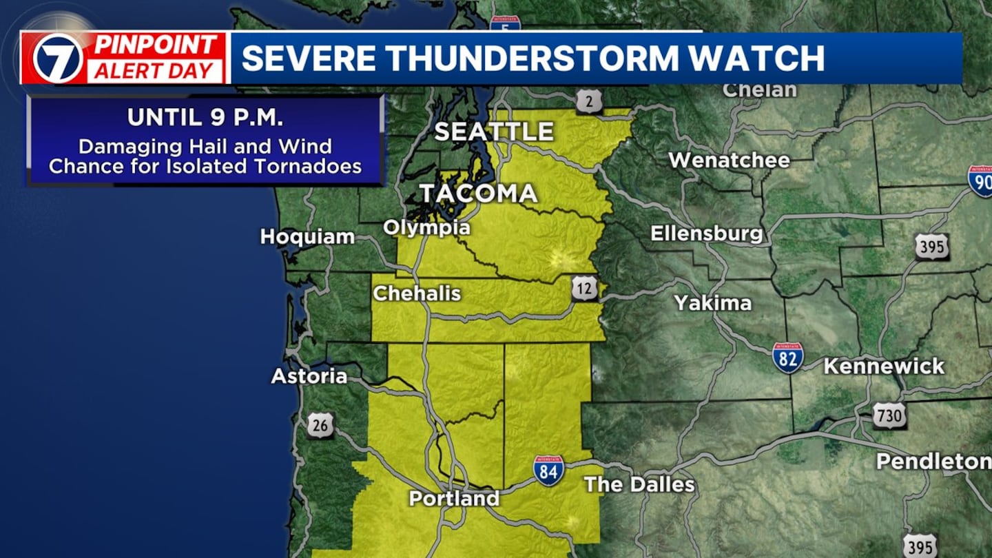
A severe thunderstorm watch has been issued for Lewis, Thurston, Pierce, and King counties until 9pm tonight.
A ‘watch’ area means severe weather can happen in and close to those areas. It is issued when severe weather is happening or will be happening.
“Of note, Seattle has never been included in a watch area since at least 1999, though areas south of Seattle were in 2017,” KIRO 7 Chief Meteorologist Morgan Palmer says.
Update 2:53pm - Chief Meteorologist Morgan Palmer
Morning cloud cover has limited daytime heating and thus reduced surface instability for thunderstorms slightly from about the Seattle area north. However, a lightning strike near Renton a short time ago signals that much colder air moving in aloft is destabilizing the atmosphere as a whole. More sunshine to the south is allowing temperatures to climb toward 70 degrees.
Expect thunderstorms to erupt down in Oregon shortly and possibly as well in the Cascades the next few hours, with isolated severe thunderstorms in the South Sound and south interior through about 5 p.m.
Pinpoint Futuretrack has strong storms affecting the South Sound, including Lewis, Thurston, Mason counties up to Tacoma from 5-7 p.m. with storms moving north impacting the Seattle area by or after 6 p.m., Everett and the North Sound by or after 7 p.m. and Bellingham and the Canadian border regions by 8-10 p.m. The timing is approximate and there will be the chance for thunderstorm activity possible outside of these “prime times” for thunderstorms moving north.
The strongest thunderstorms could well be south of the I-90 corridor and also nearer the Cascades, in the expected Watch area, and where the instability will be the greatest. However, severe weather can occur in other locations.
Large, damaging hail is the greatest threat from these storms with hail sizes possibly exceeding official Severe Thunderstorm criteria, which is wind gusts of 58 mph or greater and/or hail of one inch in diameter or larger. The last time we had a verified report of hail of one inch or larger was in Lewis County in 2017. Hail of one inch or larger can damage vehicles, roofs, and trees, and be very dangerous to anyone outside — pets too!
The tornado threat is low in the lowlands but overall a greater chance than we typically see. It’s around 5-10% with the higher percentage chances south and southeast of Seattle. Storms that do begin rotating will need to be watched closely for the chance for an isolated tornado. Of particular interest will be any rotating storms nearer the Cascades, as wind currents and rotation could be “tightened up” as storms enter foothill and mountain locations.
Lightning will be very frequent, and these storms could rival the electrical activity we experienced last August 17, when more than 3,000 lightning strikes were detected in Western Washington. This lightning is very dangerous.
Torrential rainfall will occur with these storms as well, posing a risk for drivers.
Thunderstorms will be moving northward at a rapid clip, so it will be important to keep abreast of conditions using the KIRO 7 Pinpoint Weather App. It might appear calm one minute, but then storms will quickly move in.
The strongest storms should be over by about 11pm or so, with showers lingering into Thursday. There is still the potential for a few much weaker isolated thunderstorms on Thursday with blustery and wet weather, staying wet for the Mariners game. We’ll be back in the 50s for highs with rain showers Thursday through Friday.
Update 1:57pm
Seattle Public Schools have canceled all events for this evening. All school buildings will be closed after 5pm, including the Board Community Engagement session at Rainier Beach High School set for 5:30pm.
The @NWSSPC is watching this area for the likelihood of a Severe Thunderstorm Watch being issued in the coming few hours. (Lesser chance of Tornado Watch.) #wawx #orwx pic.twitter.com/JzIqgIIEHS
— Morgan Palmer (@MorganKIRO7) March 26, 2025
Update: 1:42pm
The City of Olympia has announced it will be closing most facilities and customer service counters at 3 p.m., due to inclement weather.
Closures include The Olympia Center, Olympia Police Department customer service counter, Olympia Fire Department customer service counter, and City Hall customer service counter.
City parks in Olympia will also be closed.
The city of Kent has also canceled elementary track at Wilson Playfields, adaptive recreation track at Meridian Middle School, and the fields at Hogan park, Wilson Playfields, and Canyon Ridge Middle School are closed.
Additional school closures can be found here.
Previous:
A significant round of extreme weather is expected to sweep across Western Washington late Wednesday, bringing the threat of large, damaging hail, frequent lightning, intense downpours, and even the potential for isolated tornadoes.
After a morning of fog, clouds, and scattered showers, skies have begun to clear across parts of the region. However, cooler temperatures in roughly half the area compared to Tuesday could impact storm development — a factor forecasters are monitoring closely.
A WATCH means conditions are favorable for severe weather in the coming minutes and hours. A WARNING means the threat is imminent or is occurring!
— Morgan Palmer (@MorganKIRO7) March 26, 2025
But what triggers a Severe Thunderstorm Warning? Does a tornado have to be actually seen to spark a Tornado Warning?
I'll be live… pic.twitter.com/6hG0hGQhfn
Thunderstorms are expected to fire first along the Cascade crest during the afternoon before moving northward through Oregon and southern Washington into the evening hours. These storms will rapidly track north, with the strongest activity reaching the South Sound — including Lewis, Thurston, and Mason counties — between 5 and 7 p.m. Storms are expected to reach Tacoma by or after 7 p.m., Seattle by or after 8 p.m., and the Canadian border region between 9 and 10 p.m. This timing is approximate, and storms could occur outside of those windows as well.
A Severe Thunderstorm Watch may be issued later Wednesday, which means conditions are favorable for severe weather to develop. Seattle has never officially been included in a Severe Thunderstorm Watch, although parts of the South Sound were last included in one back on May 4, 2017.
Large hail is the greatest threat, with potential for hailstones exceeding one inch in diameter — enough to meet severe thunderstorm criteria and cause damage to cars, roofs, trees, and pose a serious risk to anyone outdoors, including pets. The last verified report of hail this size in the region was in Lewis County in 2017. Wednesday evening’s storms could be more widespread and intense.
Due to the hail risk, residents are advised to postpone outdoor activities after 4 p.m. and move vehicles under cover if possible.
While the tornado risk remains low, there is a slightly elevated chance compared to typical conditions in the lowlands, estimated at 2–5%, especially south of Seattle. Rotating storms, particularly near the Cascades, could potentially tighten up and spawn isolated tornadoes. These areas will be closely monitored.
In addition to hail and possible tornadoes, frequent lightning is expected, potentially rivaling the intense lightning storm of August 17, 2023, when over 3,000 lightning strikes were recorded in Western Washington.
Torrential rainfall is also expected with these storms, creating hazardous driving conditions.
Storms will move rapidly northward, so residents should stay updated on the latest conditions using tools like the KIRO 7 Pinpoint Weather App. Weather may appear calm just minutes before storms roll in.
Most of the severe activity is expected to wind down by around 11 p.m., though showers will linger into Thursday. A few weaker, isolated thunderstorms are possible Thursday, along with blustery and wet conditions that are likely to impact the Mariners game. Highs will return to the 50s with showers continuing into Friday.
©2025 Cox Media Group


