Click here for the latest - School & Business Closures and Alerts
Nick Allard - Wednesday Morning
*Pinpoint Alert Day continues for light snow showers & icy conditions early. Increasing mixed showers turn to all snow tonight. Alert into Thursday morning for messy conditions while driving.
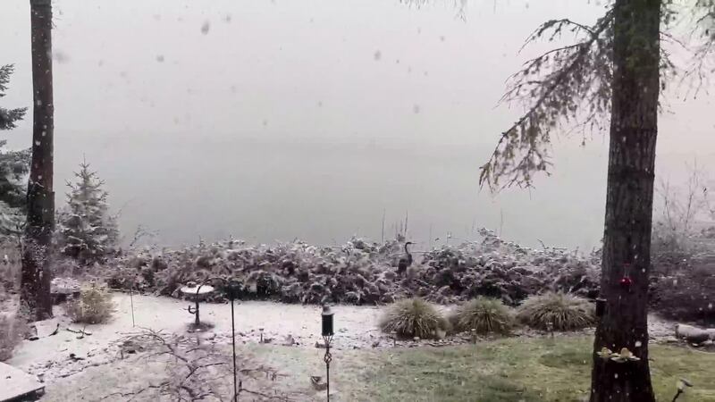
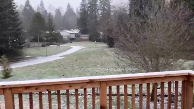
Happy Wednesday! Right on cue, some snow showers are moving through this morning with spotty light accumulation and reduced visibility in any heavier showers. Showers will be isolated, but I do think they will stick this morning with temps in the upper-20s and lower-30s. In fact, temps will continue to fall for the next couple of hours. I also see some increasing showers during the later portion of the morning commute. Just having those showers falling may slow things down. Please assume ice and if you see any new snow, be extra careful.
This next disturbance will produce a mix of rain and snow Wednesday late morning into afternoon, moving from southwest to northeast. As has been the case in recent days, the best chance for snow accumulation will be in higher elevations above 200-300 feet through early Wednesday afternoon. However, any heavier showers through the daytime hours could send some minor snow accumulations to sea level. This does not appear to be as troublesome as what could affect us Wednesday evening and Wednesday night!
On Wednesday evening through Thursday morning, temperatures will fall a bit and most areas will have to potential to see snow, instead of a wintry mix. Accumulations of snow and slush will still be spotty, but this system has the potential to put down 1-3 inches of snow in lowland locations around Puget Sound, with continued emphasis for the highest amounts on higher hills and away from large bodies of water. There could be isolated higher snow totals too. There is a Winter Weather Advisory from 10am today to 10am tomorrow for most of western Washington.
While the exact location of heavier accumulations won’t be able to be known until closer to when the snow bands or pockets move through, there is some suggestion in forecast models that the central and south Sound could be more favored for this next round. The far northern parts of the area and the Strait appear to have a much lower chance of accumulating snow with this system.
Into Thursday morning, snow showers will be decreasing but could still create issues for the morning commute. By afternoon, precipitation will have mainly ended with some sunshine emerging.
Friday morning will likely be the coldest since last January with morning lows in the upper teens to mid-20s. Friday will be mainly dry with a mix of clouds and sun.
It remains cold enough for snow at night and a rain/snow mix in the daytime through the weekend into next week. There will be the chance for some weak disturbances with moisture to move through from time to time. The first of these could affect the area on Saturday and then another possibly on Monday or Tuesday. Right now, impacts from these systems don’t look all that great but we’ll be monitoring forecast developments.
Morgan Palmer - Tuesday night
While we’ll be mainly dry for most of the time around the area into Wednesday morning, we will still have some slippery travel in a few areas early (especially areas that are adjacent to snowmelt), but the scale of icy roads won’t be as great as this morning. There will be a few light snow showers or flurries tonight into the morning, but this will be of little consequence for most of us. There could be a dusting of snow in southwestern parts of Western Washington and nearer the coast.
It will “warm” up into the mid to upper 30s by Wednesday afternoon as another round of wintry weather moves into the area through the day and continuing into Wednesday night.
This next disturbance will produce a mix of rain and snow Wednesday late morning into afternoon, moving from southwest to northeast. As has been the case in recent days, the best chance for snow accumulation will be in higher elevations above 200-300 feet through early Wednesday afternoon. However, any heavier showers through the daytime hours could send some minor snow accumulations to sea level. This does not appear to be as troublesome as what could affect us Wednesday evening and Wednesday night!
On Wednesday evening through Thursday morning, temperatures will fall a bit and most areas will have to potential to see snow, instead of a wintry mix. Accumulations of snow and slush will still be spotty, but this system has the potential to put down 1-3 inches of snow in lowland locations around Puget Sound, with continued emphasis for the highest amounts on higher hills and away from large bodies of water. There could be isolated higher snow totals too.
While the exact location of heavier accumulations won’t be able to be known until closer to when the snow bands or pockets move through, there is some suggestion in forecast models that the central and south Sound could be more favored for this next round. The far northern parts of the area and the Strait appear to have a much lower chance of accumulating snow with this system.
Into Thursday morning, snow showers will be decreasing but could still create issues for the morning commute. By afternoon, precipitation will have mainly ended with some sunshine emerging.Friday morning will likely be the coldest since last January with morning lows in the upper teens to mid 20s. Friday will be mainly dry with a mix of clouds and sun.
It remains cold enough for snow at night and a rain/snow mix in the daytime through the weekend into next week. There will be the chance for some weak disturbances with moisture to move through from time to time. The first of these could affect the area on Saturday and then another possibly on Monday or Tuesday. Right now, impacts from these systems don’t look all that great but we’ll be monitoring forecast developments.
It will remain very cold through next week with highs mainly in the upper 30s to near 40 in Seattle and morning lows in the 20s. We might come out of the cold sometime around the middle of the month.
Nick Allard - Tuesday morning
Happy Tuesday! Temps continue to fall this morning in the 20s and 30s with widespread areas of ice possible. Anything that melted yesterday, froze again last night. Please be careful and assume ice is out there. I know some of the side roads in my area were worse than yesterday, then some of the larger side roads were better. We have some isolated snow showers around the southwestern portion of Puget Sound. Most of the moisture will stay south and west of Puget Sound but will fall as snow this morning. I don’t expect much more accumulation for most of the area, but don’t be surprised if you see a quick half-inch to an inch around Shelton to Bremerton just this morning. Temps will warm this afternoon into the upper-30s with some sun breaks and much drier afternoon conditions. We also have some snow with breezy to windy weather in the Bellingham area, it’s just nasty there right now with temps, wind, and snow. It will be frigid in the low-30s and upper-20s around Whatcom County where we have Cold Weather Advisories until tomorrow morning. The wind chill readings will make it feel like it’s 7-10° at times.
As has been the case the last couple of afternoons, lowland temperatures will allow for some melting of snow on roads and sidewalks through the day Tuesday. Highs will be in the mid to upper 30s, with a shot at the low 40s where the sun can stay out for a while.
There will be a few showers overnight with much more widespread showers tomorrow morning during the commute. There should be pockets of accumulating snow during the morning that will be light and spotty, but a quick inch could be possible. Even if this doesn’t materialize, some black ice and slippery spots will be likely into midweek. Highs on Wednesday will be near 40 in Seattle.
The trough of low pressure spinning offshore — the feature responsible for this wintry weather — only slowly sags south and slowly fades by late week. We could still have passing snow showers or areas of a rain/snow mix from Wednesday afternoon through Friday, though we’ll be refining that forecast in the coming days. Overall, that period looks a bit drier.
We could have another disturbance move through this weekend with a chance of rain and snow around Saturday.
There’s no sign of any big warmup anytime very soon, and it will be into next week before we see consistent chances of daytime high temperatures getting well back into the 40s.
Morgan Palmer - Monday night
Bands of snow and rain/snow mix will continue across much of the Puget Sound region into the overnight hours, with the best chances for an inch or two of accumulation mainly away from large bodies of water, and especially at elevations above about 200 feet. These locations will be slightly colder and there will be a greater chance of snow sticking around into morning.
Elsewhere, expect some patchy ice on untreated roadways, and some bridges and overpasses into Tuesday morning. Morning lows will be in the 20s to about 30°. In Whatcom County, stout northeasterly winds out of British Columbia will keep wind chills in the single digits in some locations overnight.
By daybreak, it appears move of the precipitation will be nearer the Cascades and also west of Puget Sound. We’ll get some melting with slowly-increasing temperatures and perhaps a little sunshine at times.
More light snow showers are possible later Tuesday before another chance of snow or rain/snow mix on Wednesday.
Morgan Palmer - Monday afternoon
Very cold temperatures continue with scattered showers of snow around the region this afternoon, with some rain mixed in at sea level. As temperatures fall later this evening, expect that precipitation to be just about all snow where it occurs. As these spotty showers move through, some of the heavier ones will produce some minor snow accumulation — mainly two inches or less in any lowland location. A bit more snow could fall at the north coast and nearer the mountains into tonight.
Temperatures will settle into the 20s to about 30 early Tuesday morning, and especially on bridges, overpasses, rural and neighborhood roads, and some untreated roadways, there will be some slippery spots from refreezing of moisture. In portions of Whatcom County, near the mountains, and anywhere snow remains on roads and sidewalks, it will be crunchy and icy into Tuesday morning. It will be windy in Whatcom County with the overnight wind chills in the single digits to low teens.
As has been the case the last couple afternoons, lowland temperatures will allow for some melting of snow on roads and sidewalks through the day Tuesday. Highs will be in the mid to upper 30s, with a shot at the low 40s where sun can stay out for a while.
Into Tuesday night and early Wednesday morning, there could be another round of snow showers across the area. Even if this doesn’t materialize, some black ice and slippery spots will be likely into midweek. Highs on Wednesday will be near 40 in Seattle.
The trough of low pressure spinning offshore — the feature responsible for this wintry weather — only slowly sags south and slowly fades by late week. We could still have passing snow showers or areas of a rain/snow mix from Wednesday afternoon through Friday, though we’ll be refining that forecast in the coming days. Overall, that period looks a bit drier.
We could have another disturbance move through this weekend with a chance of rain and snow around Saturday.
There’s no sign of any big warmup anytime very soon, and it will be into next week before we see consistent chances of daytime high temperatures getting well back into the 40s.
Nick Allard - Monday morning
Happy Monday! This morning, we have temps in the lower-30s for most of the area, a degree or two on either side of 32°. Plenty of spots will be icy, especially side roads so be careful. We have some very light snow showers or flurries this morning that are spotty and will continue to be spotty early on. I don’t really expect accumulation, except maybe in the Cascade Foothills, and even then, the showers will be light. The same upper-level trough is still offshore with increasing Fraser River Outflow in Whatcom County. Northeast wind will keep the North Interior very cold today with wind chill readings even worse. Bellingham is around 22° this morning, but with a 20 mph gust, it feels like 8°. Being outside for too long is dangerous, so please keep that in mind.
The upper-level trough will keep pushing some pockets of showers over the area today, but it will be calmer overall compared to yesterday. Temps will warm to above freezing so expect some melting, before of course, it freezes again tonight. Areas influenced by the Fraser River Outflow will barely make it to freezing today, if at all, and anything that falls over the North Interior should be snow. We have Cold Weather Advisories because of the wind chill for parts of the North Interior until later this morning, but it’s something you should be prepared for all day.
Showers should pick up a bit more later this afternoon and evening and will fall during the evening commute. Also, some spotty accumulation around and up to around an inch or so could fall across much of western Washington into tomorrow morning. Everything will be very spotty. Temps will fall back into the upper-20s and lower-30s, so please be prepared for icy spots again tomorrow morning.
Tomorrow will be very similar with some spotty mix showers and temps warming into the mid and upper-30s.
There are chances for spotty flurries or a few very light snow showers through Wednesday, though it’s expected to not be of any significance for most of the area based on present forecast data. The mountains could pick up some light accumulations. We’ll be watching the week’s forecast details closely as they evolve, as any additional moisture sent our way could increase snow chances some. But for now, it’s looking mainly dry though the week with just some flurries at times through Wednesday.
There is the potential, although it’s too early for much detail, for more wintry mix showers this weekend.
0 of 9


Morgan Palmer - 9:42 p.m. Sunday
We have had some vigorous showers of snow and rain/snow mix this Sunday and even three reports of “thundersnow” from especially strong snow squalls — two in Whatcom County and also a lightning strike near Burien. In addition, there was at least one waterspout sighted off Birch Bay in the waters off Whatcom County earlier today.
As the atmosphere stabilizes somewhat into the overnight, we’re seeing the expected decrease in coverage and intensity of snow showers, but we’ll continue to have some periods of light now overnight, as well as some heavier snow in parts of Whatcom County and near the coast.
A Winter Weather Advisory continues for all locations in the lowlands except for coastal King, Snohomish counties and Island County. In these spots, any accumulation should be very minimal. In other spots, isolated 1-2 inch snow is possible.
Even in spots that don’t have snow tonight and into Monday morning, there will be some icy patches on roads from freezing water or snowmelt. Drivers should be especially careful early Monday on untreated, side roads and residential streets. It’s expected that main roads should remain fairly good, particularly treated roadways.
Morning lows will be in the 20s. In western Whatcom County, gusty winds out of British Columbia will force wind chills into the single digits early Monday.
While there could still be some spotty snow showers later on Monday morning, it’ll likely be drier in most areas with some breaks of sunshine. Highs will be in the 30s to near 40.
Another round of light snow is possible Monday evening into Monday night. Any accumulations should be minimal but won’t melt until later Tuesday.
There are chances for spotty flurries or a few very light snow showers Tuesday through Wednesday, though it’s expected to not be of any significance for most of the area based on present forecast data. The mountains could pick up some light accumulations. We’ll be watching the week’s forecast details closely as they evolve, as any additional moisture sent our way could increase snow chances some. But for now, it’s looking mainly dry though the week with just some flurries at times through Wednesday.
KIRO 7 News Staff - 9:04 p.m.
Multiple collisions have been reported throughout Puget Sound, including a state patrol car hit on southbound Interstate 5 near Southcenter Sunday evening.
At about 8:19 p.m., a Washington State Patrol car was hit near 188th, causing a large backup of vehicles.
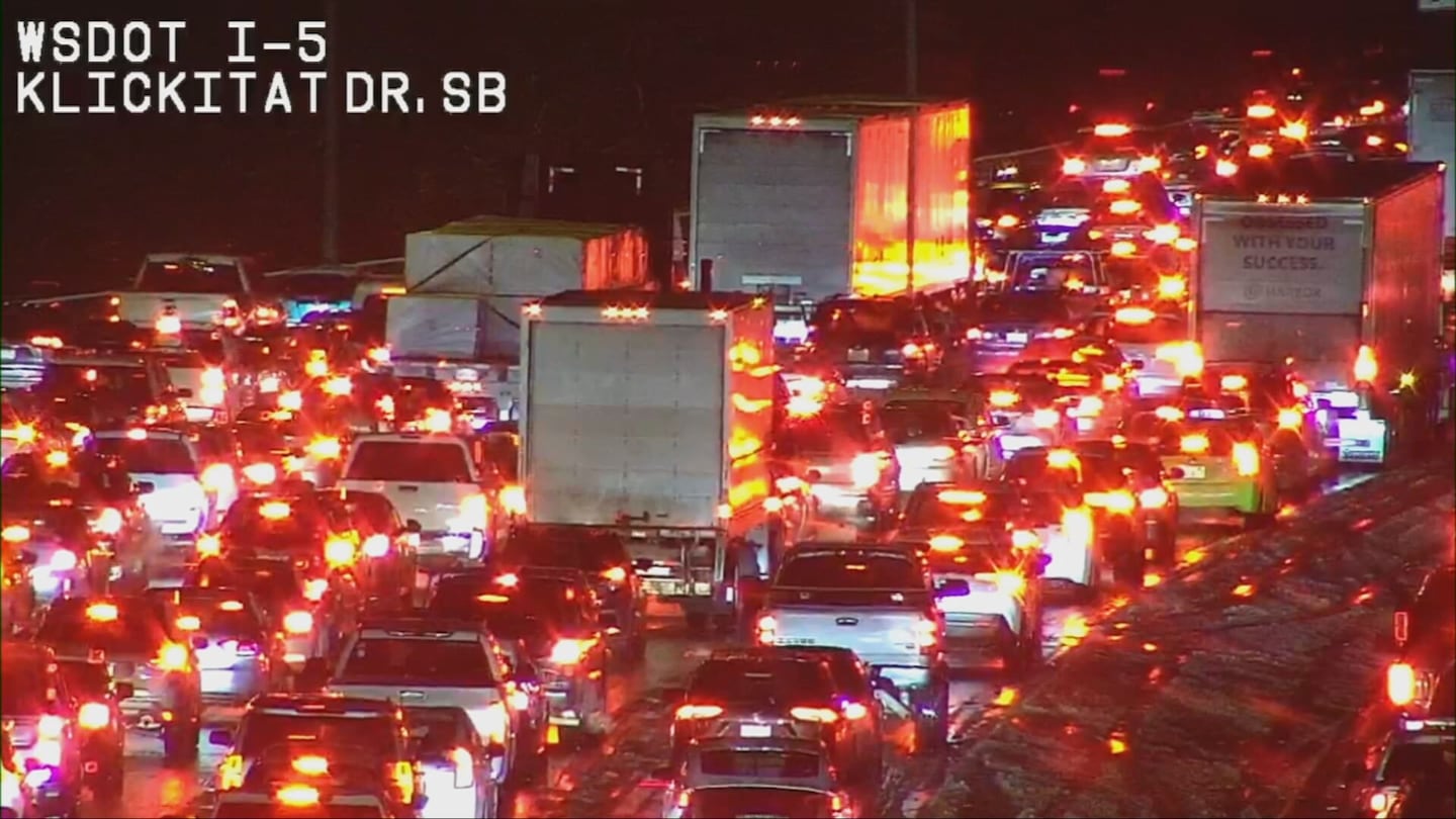
According to sigalert.com, the backup extended from approximately Military Road to I-405.
There were no serious injuries.
“If you don’t need to travel please do not. If you do, take it slow,” Trooper Rick Johnson said in a post on X.
Morgan Palmer
As pockets of snow work through Western Washington, a few of them have been vigorous enough to produce something very unusual in Western Washington: lightning, thunder, and even a waterspout while snow is going on!
KIRO 7 News Staff - 5:26 p.m.
Both directions of SR 18 are blocked over Tiger Mountain Summit for a disabled vehicle blocking all lanes.
There is no estimated time for reopening.
CLOSED: Eastbound and westbound SR 18 at Tiger Mountain summit (MP 24) is now closed due to stalled vehicles in both directions, along with heavy snow.
— WSDOT Traffic (@wsdot_traffic) February 3, 2025
Please use alternate routes. There is no ETA for reopening at this time. pic.twitter.com/TMh1xgbqtD
Collision reported on SR 8 WB at MP 15.41 near Kennedy Cr Rd SW beginning at 5:31 pm on Feb. 2, 2025 until further notice. The left lane is reported to be blocked.
— WSDOT Tacoma (@wsdot_tacoma) February 3, 2025
KIRO 7 News Staff - 3:48 p.m.
Pioneer School District near Shelton announced Sunday it will be running two hours late with no AM preschool on Monday.
Eatonville School District and Lake Quinault School District will be two hours late on Monday.
Southside School District will be 90 minutes late.
For all school closings and delays, visit our page here.
This driver tried to take the side road between MP 42 and 47 near EB 90. Maybe trying to avoid chaining up?? Either way the tow bill will not be cheap. pic.twitter.com/Awz2XlOaHw
— Trooper Rick Johnson (@wspd2pio) February 2, 2025
Morgan Palmer
Snow showers and rain/snow mix at sea level has been observed Sunday and this will continue through the remainder of the day. Most favored locations for snowfall with mainly minor accumulations are areas south of Seattle at elevations above about 300 feet, the north coast and Olympic Peninsula, and western Whatcom County.
Elsewhere, including Seattle, Tacoma, and Everett nearer sea level, the combination of slightly warmer temperatures and “snow shadowing” behind the Olympic Mountains will limit precipitation and accumulation.
Still, anywhere snow falls for an extended period of time, accumulations will result. Use caution driving the remainder of the day today and into tonight, when temperatures will fall.
Overall coverage of precipitation tapers into Sunday night and Monday morning, though there will still be some pockets of snow in the lowlands and the mountains. The best chance of snow tonight will be along the coast, south of Tacoma, and possibly western Whatcom County and along the Strait.
Even in spots that don’t have snow tonight and into Monday morning, there could be some icy patches on roads from freezing of water or snowmelt. Drivers should be especially careful early Monday on untreated, side roads and residential streets. It’s expected that main roads should remain fairly good, particularly treated roadways.
Morning lows will be in the 20s. In western Whatcom County, gusty winds out of British Columbia will force wind chills into the single digits early Monday.
While there could still be some spotty snow showers later on Monday morning, it’ll likely be dry in most areas with some breaks of sunshine. Highs will be in the 30s to near 40.
There are chances for spotty flurries or a few very light snow showers Monday night through Wednesday, though it’s expected to not be of any significance for most of the area based on present forecast data. The mountains could pick up some light accumulations. We’ll be watching the week’s forecast details closely as they evolve, as any additional moisture sent our way could increase snow chances some. But for now, it’s looking mainly dry though the week with just some flurries at times through Wednesday.
There could be another chance of snow or rain/snow mix by next weekend, though details are murky.
KIRO 7 News Staff - 1:39pm
Eastbound I-90, west of Snoqualmie Pass, has reopened to traffic.
CLEARED: Eastbound I-90 west of the Snoqualmie Pass summit is back open. https://t.co/cuYq8uHqSn
— WSDOT Traffic (@wsdot_traffic) February 2, 2025
KIRO 7 News Staff - 12:52pm
Eastbound Interstate 90 at milepost 47 is now closed, west of Snoqualmie Pass summit, due to a crash. At this time, there is no estimated time of reopening.
We have EB I-90 at MP 47 closed, west of the Snoqualmie Pass summit due to blocking collisions. No ETA to reopen. Plan for added travel time.
— Snoqualmie Pass (@SnoqualmiePass) February 2, 2025
According to FlightAware, SEA is #1 on the Misery Map, accounting for 54 flight delays and four cancellations.
Heavy snow in Federal Way at 10:15 AM! Sticking to all surfaces, and accumulating over 0.25”!! #wawx @NWSSeattle pic.twitter.com/Y0XxLHIVae
— Matthew Pfab (@The_Weatherman2) February 2, 2025
Approximately 6,892 customers are without power throughout Western Washington, including 5,914 in Clallam County and 936 for Puget Sound Energy.
Morgan Palmer
We continue to see snow showers (pockets of snow, sometimes mixed with rain) continue to move onshore from the Pacific, and through this Sunday that will continue. Temperatures nearer sea level in most of our cities will be in the upper 30s to around 40 today, so just like Saturday, most lowland accumulations won’t last very long.
However, it doesn’t take long for a bit of slush and snow to accumulate on roads and sidewalks, so be very careful if out and about today.
The most favored areas for any accumulation that could cause travel issues will be in foothill locations, Whatcom County, Snohomish and Skagit Counties, along the Strait and the coast (mainly away from the beaches), and any spots above 300 feet in elevation. A Winter Weather Advisory is in effect for most of these areas.
In addition, there is the chance for an isolated lightning strike and hail shower Sunday, though this chance is pretty isolated. This could cause brief travel difficulty where ice pellets showers occur.
In the mountains, snow showers will continue through the day with more accumulations at times!
Through early Sunday evening, we’ll have some melting where wet snow falls in the lowlands and also some moisture from rain. But then temperatures fall. We will have some icy patches by Monday morning as temperatures drop a bit below freezing, so drivers beware. We’ll also have a better chance for any lowland snow to actually stick around for a while, creating minor accumulations.
I anticipate there’s a good chance of some school delays and possibly closures Monday, though that will be far more the exception than the rule. We will have you covered on the morning commute and school delays on KIRO 7 News in the Morning Monday from 4:30 a.m.
For Monday, the most likely areas to have impact from snow and icy roads will again be in the previously-mentioned areas of the foothills of the Cascades, Eastside communities (especially above a few hundred feet elevation), parts of the North Sound (especially from South Everett east through Lake Stevens and south to Snohomish and Mill Creek), Western Whatcom County and the San Juans and western Skagit County and the coast and Strait.
It continues to be important to note that while most of the area will not have significant snowy or icy travel through this period, most locations will have precipitation of some sort — be it rain, a rain/snow mix, or lightly-or-non accumulating snow. Be careful out driving because even if temperatures are above freezing, heavier precipitation that includes wet snow could cause slippery and slushy travel.
Through Monday afternoon, a very slow drying trend is noted but the precipitation type on Monday is more likely to be all snow. However, further accumulations after Monday morning should be mainly light and isolated. Highs will only be in the 30s. A few flurries are likely Tuesday with lows in the 20s and highs in the 30s.
Cedar Falls Way in North Bend. @CityofNorthBend @NWSSeattle pic.twitter.com/5e9x2bc3yd
— North Bend WA Weather 🇺🇸 (@northbendwx) February 2, 2025
While we maintain a mainly dry forecast, the remainder of the week beyond next Tuesday, there could be further chances for light snow we will evaluate as new data come in. This forecast for later next week is very uncertain.
It is likely to be quite cold from Tuesday through Friday with morning lows in the teens to mid-20s and highs in the low-to-mid 30s. This cold will be dangerous for the unhoused.
Also, be thinking and acting now about how you will keep your exposed exterior faucets and pipes protected, and make sure pets and animals have a warm place to be. Also, make sure (if able) to check on neighbors who might have trouble with heat.
©2025 Cox Media Group